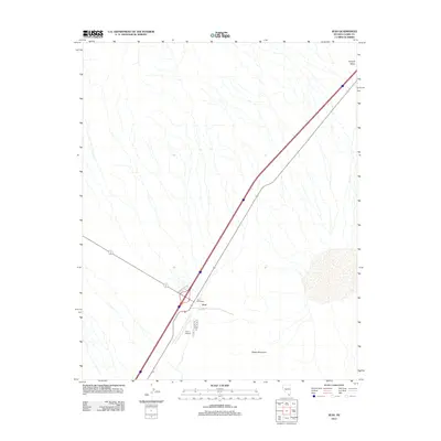
2012 Map of Jean
USGS Topo · Published 2012About this map
Jean sits at a critical junction of transportation and logistics in the high desert, serving as a concentrated hub within the wide expanse of the Ivanpah Valley. This 2012 survey illustrates the settlement's function as a waypoint, anchored by the Jean Post Office and the neighboring Jean Airport. The landscape is defined by its infrastructure, where Goodsprings Rd and Prison Rd branch off from the primary corridor. To the southeast, the terrain rises toward the slopes of Sheep Mountain, providing a stark natural contrast to the engineered regularity of the valley floor. The map captures the area's modern identity as a transit and service node, clearly delineating the relationship between the small community center and the vast alluvial fans and dry washes that characterize this portion of Clark County.
Find a feature on this map
7 named features on this map. Tap any name to fly to it.
Don’t see what you’re looking for? This feature index may not catch every label — zoom into the map to look around manually.
Map Details
Editions of this 2012 Jean Map
This is the sole edition of this map. No revisions or reprints were ever made.
Other maps of this area

1910 · Ivanpah
USGS Topo · 1:250,000

1912 · Ivanpah
USGS Topo · 1:250,000

1942 · Ivanpah
USGS Topo · 1:250,000

1947 · Kingman
USGS Topo · 1:250,000

1948 · Kingman
USGS Topo · 1:250,000

1954 · Kingman
USGS Topo · 1:250,000

1955 · Kingman
USGS Topo · 1:250,000

1955 · Roach Lake
USGS Topo · 1:62,500

1958 · Kingman
USGS Topo · 1:250,000

1960 · Kingman
USGS Topo · 1:250,000