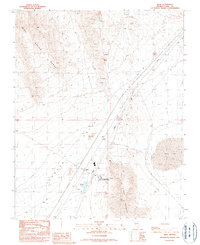
1989 Map of Jean
USGS Topo · Published 1990About this map
Ivanpah Valley dominates this 1989 topographical study, revealing a desert landscape increasingly defined by utility and institutional development. The small settlement of Jean sits at a crossroads of infrastructure, flanked by a local Airport and a series of sewage disposal ponds. To the east, the sprawling dry bed of Jean Lake contrasts with the steep elevations of Sheep Mountain and the western Bird Spring Range. A significant human imprint is visible through the Southern Nevada Correctional Center and a long pipeline cutting across the valley floor. The map also documents the area's industrial activity, with numerous prospects, a quarry, and several gravel pits scattered near the rail and road corridors, illustrating how the region's mineral potential was surveyed during the late twentieth century.
Find a feature on this map
20 named features on this map. Tap any name to fly to it.
Don’t see what you’re looking for? This feature index may not catch every label — zoom into the map to look around manually.
Map Details
Editions of this 1989 Jean Map
This is the sole edition of this map. No revisions or reprints were ever made.
Other maps of this area

1910 · Ivanpah
USGS Topo · 1:250,000

1912 · Ivanpah
USGS Topo · 1:250,000

1942 · Ivanpah
USGS Topo · 1:250,000

1947 · Kingman
USGS Topo · 1:250,000

1948 · Kingman
USGS Topo · 1:250,000

1954 · Kingman
USGS Topo · 1:250,000

1955 · Kingman
USGS Topo · 1:250,000

1955 · Roach Lake
USGS Topo · 1:62,500

1958 · Kingman
USGS Topo · 1:250,000

1960 · Kingman
USGS Topo · 1:250,000