Loading...
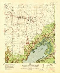
Loading map...1941 Map of Jena
USGS Topo · Published 1943About this map
Jena stands at the center of this 1941 landscape, a crucial hub where the Louisiana & Arkansas RR connects timber and commerce across La Salle Parish. The settlement pattern reflects a deeply rooted community, with small clusters like Trout, Good Pine, and Midway lining the transit corridor. To the south, the terrain descends from the higher ground of the escarpment into the expansive wetlands of the Alluvial Valley, dominated by the massive reach of Catahoula Lake.
Find a feature on this map
62 named features on this map. Tap any name to fly to it.
Don’t see what you’re looking for? This feature index may not catch every label — zoom into the map to look around manually.
Map Details
Date Portrayed1941
Date Published1943
PublisherU.S. Geological Survey
Map TypeTopographic
Scale1:62,500
Physical Dimensions17.9 x 21.8 inches
Editions of this 1941 Jena Map
This is the sole edition of this map. No revisions or reprints were ever made.
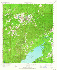
Historical Maps of Jena Through Time
Featured Locations
Source Details
SourceU.S. Geological Survey
CopyrightPublic Domain