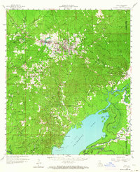
1958 Map of Jena
USGS Topo · Published 1964About this map
The town of Jena serves as the focal point for this mid-century survey of the LaSalle and Catahoula Parish borderlands, an area defined by the meeting of timbered uplands and the vast basin of Catahoula Lake. This period captures the region's industrial transition, where the Louisiana and Arkansas Railway connects timber-focused settlements like Trout and Good Pine to larger markets, while the Nebo Hemphill Oil Field and West Catahoula Lake Oil Field indicate the growing importance of petroleum extraction.
Find a feature on this map
102 named features on this map. Tap any name to fly to it.
Don’t see what you’re looking for? This feature index may not catch every label — zoom into the map to look around manually.
Map Details
Editions of this 1958 Jena Map
2 editions found

Other maps of this area

1935 · Tooleys
USGS Topo · 1:62,500

1936 · Pollock
USGS Topo · 1:62,500

1941 · Manifest
USGS Topo · 1:62,500

1941 · Jena
USGS Topo · 1:62,500

1941 · Alexandria
USGS Topo · 1:62,500

1941 · Buckeye
USGS Topo · 1:62,500

1941 · Pollock
USGS Topo · 1:62,500

1941 · Tooleys
USGS Topo · 1:62,500

1941 · Harrisonburg
USGS Topo · 1:62,500

1953 · Alexandria
USGS Topo · 1:250,000