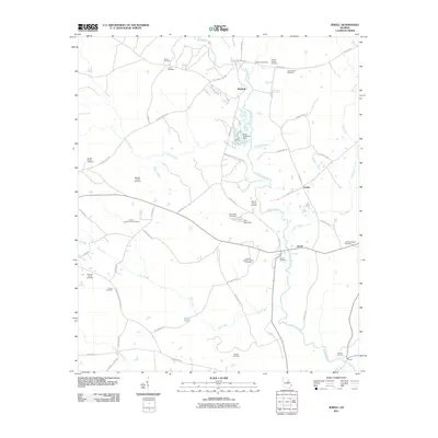
2011 Map of Jewell
USGS Topo · Published 2011About this map
Ogeechee River meanders through this portion of Georgia, defining a landscape marked by small riverside settlements and a dense concentration of family-named burial grounds. From Mayfield in the north to Shoals at the southern boundary, the map reveals a rural geography where community life has long centered on small hamlets like Jewell and Ansley. The area's agricultural and social history is deeply etched in its many family plots, including the Gonder Family Cemetery, Medlock Family Cemetery, and Evans-Taylor Cemetery.
Find a feature on this map
58 named features on this map. Tap any name to fly to it.
Don’t see what you’re looking for? This feature index may not catch every label — zoom into the map to look around manually.
Map Details
Editions of this 2011 Jewell Map
This is the sole edition of this map. No revisions or reprints were ever made.
Other maps of this area

1953 · Athens
USGS Topo · 1:250,000

1958 · Athens
USGS Topo · 1:250,000

1959 · Athens
USGS Topo · 1:250,000

1960 · Warthen NE
USGS Topo · 1:24,000

1961 · Warthen NW
USGS Topo · 1:24,000

1963 · Athens
USGS Topo · 1:250,000

1971 · Beall Springs
USGS Topo · 1:24,000

1972 · Sparta NW
USGS Topo · 1:24,000
1972 · Jewell
USGS Topo · 1:24,000
1972 · Mitchell
USGS Topo · 1:24,000