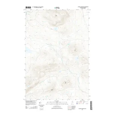
2014 Map of Jo-Mary Mountain
USGS Topo · Published 2014About this map
The Appalachian National Scenic Trail winds through the northwestern corner of this territory, passing near the shores of Crawford Pond. This 2014 survey reveals a landscape of high summits and intricate water systems in Piscataquis County. Centered on the prominence of Jo-Mary Mountain, the terrain drops toward the East Branch Pleasant River, which serves as a central drainage for numerous mountain brooks. Significant elevation changes are marked by dramatic water features, including Gauntlet Falls and Mud Gauntlet Falls. The area is accessible primarily via Johnson Rd and Jo-Mary Rd, highlighting a timber-and-recreation landscape where industrial forest roads provide the only vehicle access to remote peaks like Cedar Mtn and the isolated Mud Gauntlet Deadwater. This map preserves the contemporary state of these northern Maine woods, documenting the specific intersection of recreational trail systems and working forest infrastructure.
Find a feature on this map
30 named features on this map. Tap any name to fly to it.
Don’t see what you’re looking for? This feature index may not catch every label — zoom into the map to look around manually.
Map Details
Editions of this 2014 Jo-Mary Mountain Map
This is the sole edition of this map. No revisions or reprints were ever made.
Other maps of this area

1940 · Sebec
USGS Topo · 1:48,000

1943 · Sebec
USGS Topo · 1:62,500

1947 · Schoodic
USGS Topo · 1:62,500

1949 · Schoodic
USGS Topo · 1:62,500

1951 · Norcross
USGS Topo · 1:62,500

1952 · Jo-Mary Mountain
USGS Topo · 1:62,500

1954 · Millinocket
USGS Topo · 1:250,000

1958 · Millinocket
USGS Topo · 1:250,000

1960 · Millinocket
USGS Topo · 1:250,000
1978 · Silver Lake
USGS Topo · 1:24,000