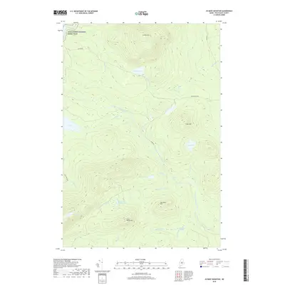
2018 Map of Jo-Mary Mountain
USGS Topo · Published 2018About this map
The Appalachian National Scenic Trail winds through the northwest corner of this remote Piscataquis County landscape, crossing Cooper Brook near the northern boundary. Dominated by the significant elevations of Jo-Mary Mtn, Cedar Mtn, and the Wilkie peaks, the area is defined by a complex drainage network feeding the East Branch Pleasant River. This river system includes distinctive features like Gauntlet Falls and Mud Gauntlet Falls, along with several large still waters such as Johnston Pond and Gauntlet Pond. The presence of established logging corridors like B Pond Rd and Jo Mary Rd alongside the historic footpath illustrates the ongoing dual use of the North Woods for both industrial timber management and wilderness recreation in the early twenty-first century. These roads provide access to the various deadwaters and brooks that characterize the interior of the quadrangle.
Find a feature on this map
32 named features on this map. Tap any name to fly to it.
Don’t see what you’re looking for? This feature index may not catch every label — zoom into the map to look around manually.
Map Details
Editions of this 2018 Jo-Mary Mountain Map
This is the sole edition of this map. No revisions or reprints were ever made.
Other maps of this area

1940 · Sebec
USGS Topo · 1:48,000

1943 · Sebec
USGS Topo · 1:62,500

1947 · Schoodic
USGS Topo · 1:62,500

1949 · Schoodic
USGS Topo · 1:62,500

1951 · Norcross
USGS Topo · 1:62,500

1952 · Jo-Mary Mountain
USGS Topo · 1:62,500

1954 · Millinocket
USGS Topo · 1:250,000

1958 · Millinocket
USGS Topo · 1:250,000

1960 · Millinocket
USGS Topo · 1:250,000
1978 · Silver Lake
USGS Topo · 1:24,000