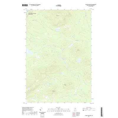
2021 Map of Jo-Mary Mountain
USGS Topo · Published 2021About this map
The Appalachian National Scenic Trail traverses the northwest corner of this Piscataquis County landscape, passing just north of Jo-Mary Mtn and crossing Johnson Rd. This high-elevation terrain is defined by a series of prominent peaks and interior basins, including Cedar Mtn and the dual summits of Big Wilkie Mtn and Little Wilkie Mtn. The hydrology of the area is particularly complex, characterized by the winding path of the East Branch Pleasant River and several distinct 'deadwaters'—stagnant or slow-moving stretches of water common in this region—such as Mud Gauntlet Deadwater and Babble Brook Deadwater. Numerous remote water bodies like Johnston Pond, Gauntlet Pond, and the aptly named Crater Pond are connected by a network of logging roads including B Pond Rd and Jo Mary Rd.
Find a feature on this map
20 named features on this map. Tap any name to fly to it.
Don’t see what you’re looking for? This feature index may not catch every label — zoom into the map to look around manually.
Map Details
Editions of this 2021 Jo-Mary Mountain Map
This is the sole edition of this map. No revisions or reprints were ever made.
Other maps of this area

1940 · Sebec
USGS Topo · 1:48,000

1943 · Sebec
USGS Topo · 1:62,500

1947 · Schoodic
USGS Topo · 1:62,500

1949 · Schoodic
USGS Topo · 1:62,500

1951 · Norcross
USGS Topo · 1:62,500

1952 · Jo-Mary Mountain
USGS Topo · 1:62,500

1954 · Millinocket
USGS Topo · 1:250,000

1958 · Millinocket
USGS Topo · 1:250,000

1960 · Millinocket
USGS Topo · 1:250,000
1978 · Silver Lake
USGS Topo · 1:24,000