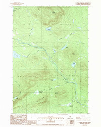
1988 Map of Jo-Mary Mountain
USGS Topo · Published 1988About this map
Jo-Mary Mountain and Big Wilkie Mountain anchor this landscape of the Maine North Woods in the late 1980s. The area is defined by the complex hydrology of the East Branch Pleasant River, which is fed by numerous named brooks and ponds. The river's path is marked by distinctive whitewater and calm stretches, notably Gauntlet Falls and the Mud Gauntlet Deadwater. This topography reveals the intensive water-management and transport network used in regional timber operations, including a Trestle Brook and access points like Guernsey Brook. The map also details the administrative divisions of the Unorganized Territory, spanning portions of T A R 11 W E L S and T A R 10 W E L S, providing a clear view of the wilderness geography before the turn of the 21st century.
Find a feature on this map
31 named features on this map. Tap any name to fly to it.
Don’t see what you’re looking for? This feature index may not catch every label — zoom into the map to look around manually.
Map Details
Editions of this 1988 Jo-Mary Mountain Map
This is the sole edition of this map. No revisions or reprints were ever made.
Other maps of this area

1940 · Sebec
USGS Topo · 1:48,000

1943 · Sebec
USGS Topo · 1:62,500

1947 · Schoodic
USGS Topo · 1:62,500

1949 · Schoodic
USGS Topo · 1:62,500

1951 · Norcross
USGS Topo · 1:62,500

1952 · Jo-Mary Mountain
USGS Topo · 1:62,500

1954 · Millinocket
USGS Topo · 1:250,000

1958 · Millinocket
USGS Topo · 1:250,000

1960 · Millinocket
USGS Topo · 1:250,000
1978 · Silver Lake
USGS Topo · 1:24,000