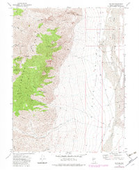
1972 Map of Job Peak
USGS Topo · Published 1982About this map
Job Peak towers over the rugged divide between the high peaks of the Stillwater Range and the expansive desert floor of the Dixie Valley. The landscape is defined by its dramatic verticality, where steep drainage systems like Big Box Canyon, Middle Fork Pete Canyon, and South Fork Pete Canyon carve through the mountains toward the valley below. This 1970s survey illustrates a wilderness primarily utilized for ranching and resource extraction, evidenced by scattered infrastructure such as a Corral and a Gravel Pit.
Find a feature on this map
26 named features on this map. Tap any name to fly to it.
Don’t see what you’re looking for? This feature index may not catch every label — zoom into the map to look around manually.
Map Details
Editions of this 1972 Job Peak Map
2 editions found
Other maps of this area

1908 · Carson Sink
USGS Topo · 1:250,000

1910 · Carson Sink
USGS Topo · 1:250,000

1957 · Reno
USGS Topo · 1:250,000

1959 · Reno
USGS Topo · 1:250,000

1960 · Reno
USGS Topo · 1:250,000

1969 · Cox Canyon
USGS Topo · 1:24,000

1969 · Table Mtn
USGS Topo · 1:24,000

1972 · Pirouette Mtn
USGS Topo · 1:24,000
1972 · I X L Canyon
USGS Topo · 1:24,000
1972 · Job Peak
USGS Topo · 1:24,000