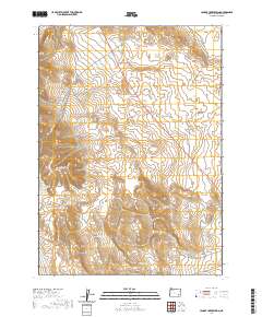
2020 Map of Johnny Creek Spring
USGS Topo · Published 2020About this map
Saddle Butte Lava Field dominates the high-desert topography of this Malheur County landscape, where the volcanic history of the region is etched into the terrain. The northern stretches of the Sheepshead Mountains rise in the west, while Cone Ridge provides a distinct landmark near the center. The drainage patterns of the Great Basin are clearly visible through the seasonal paths of Ryegrass Creek and its southern fork, which cut through the arid soil towards the lower elevations. Human presence in this isolated portion of southeastern Oregon is sparse, represented primarily by the winding route of N Fork Ryegrass Creek Rd and the township and range lines that demarcate the public land survey system. Along the southern border, the headwaters of Johnny Creek emerge, further illustrating the complex hydrology of these remote uplands.
Find a feature on this map
13 named features on this map. Tap any name to fly to it.
Don’t see what you’re looking for? This feature index may not catch every label — zoom into the map to look around manually.
Map Details
Editions of this 2020 Johnny Creek Spring Map
This is the sole edition of this map. No revisions or reprints were ever made.
Other maps of this area

1955 · Jordan Valley
USGS Topo · 1:250,000

1955 · Burns
USGS Topo · 1:250,000

1955 · Adel
USGS Topo · 1:250,000

1955 · Boise
USGS Topo · 1:250,000

1957 · Adel
USGS Topo · 1:250,000

1957 · Jordan Valley
USGS Topo · 1:250,000

1958 · Burns
USGS Topo · 1:250,000

1958 · Boise
USGS Topo · 1:250,000

1958 · Adel
USGS Topo · 1:250,000

1958 · Jordan Valley
USGS Topo · 1:250,000