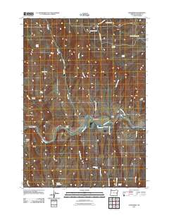
2011 Map of Jonesboro
USGS Topo · Published 2011About this map
Jonesboro serves as the focal point for this high-desert landscape in Malheur County, situated along the corridor where the Malheur River and the Jonesboro Canal provide critical water access. The settlement pattern is defined by the proximity to these water sources, illustrated by the Vaughn Peach Ranch and the D Jones Ranch positioned near the riverbank. This area is a network of canyons and gulches, including Black Canyon and Chalk Gulch, which drain toward the river from the surrounding uplands. Ranching infrastructure is evident in the numerous named water sources like Buckboard Spring and Antelope Spring, alongside reservoirs such as Peavine Reservoir and Bristol Reservoir. The terrain transitions from the elevations of Stemler Ridge and Stemler Basin in the west toward the broken country of Big Swamp Creek and Road Gulch to the east.
Find a feature on this map
35 named features on this map. Tap any name to fly to it.
Don’t see what you’re looking for? This feature index may not catch every label — zoom into the map to look around manually.
Map Details
Editions of this 2011 Jonesboro Map
This is the sole edition of this map. No revisions or reprints were ever made.
Other maps of this area

1955 · Burns
USGS Topo · 1:250,000

1955 · Boise
USGS Topo · 1:250,000

1958 · Burns
USGS Topo · 1:250,000

1958 · Boise
USGS Topo · 1:250,000

1959 · Burns
USGS Topo · 1:250,000

1962 · Boise
USGS Topo · 1:250,000

1966 · Westfall Butte
USGS Topo · 1:62,500

1966 · Beulah
USGS Topo · 1:62,500

1972 · Tims Peak
USGS Topo · 1:24,000
1972 · Monument Peak
USGS Topo · 1:24,000