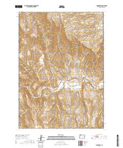
2020 Map of Jonesboro
USGS Topo · Published 2020About this map
The Malheur River cuts a distinct horizontal path through this high desert terrain in Malheur County, providing the primary water source for local ranching and agriculture. The reliance on water management is evident in the Jonesboro Canal, which diverts flow along the river valley, and various upland water sources like Peavine Reservoir and Bristol Reservoir. The landscape is defined by its numerous drainages and springs, including Big Swamp Cr and Dipping Vat Cr, suggesting a history of livestock grazing and range management. High points like Stemler Ridge and the Stemler Basin overlook complex geological features such as Currey Canyon and Chalk Gulch. Seasonal hydrology is marked by named springs like Buckboard Spring and Saddlehorse Spring, which served as critical landmarks in an area dominated by open range and limited road access via Pole Creek Rd.
Find a feature on this map
42 named features on this map. Tap any name to fly to it.
Don’t see what you’re looking for? This feature index may not catch every label — zoom into the map to look around manually.
Map Details
Editions of this 2020 Jonesboro Map
This is the sole edition of this map. No revisions or reprints were ever made.
Other maps of this area

1955 · Burns
USGS Topo · 1:250,000

1955 · Boise
USGS Topo · 1:250,000

1958 · Burns
USGS Topo · 1:250,000

1958 · Boise
USGS Topo · 1:250,000

1959 · Burns
USGS Topo · 1:250,000

1962 · Boise
USGS Topo · 1:250,000

1966 · Westfall Butte
USGS Topo · 1:62,500

1966 · Beulah
USGS Topo · 1:62,500

1972 · Tims Peak
USGS Topo · 1:24,000
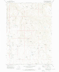
1972 · Monument Peak
USGS Topo · 1:24,000