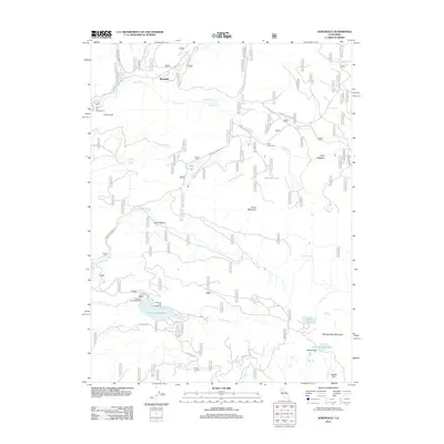
2012 Map of Jonesville
USGS Topo · Published 2012About this map
Jonesville serves as the focal point for this high-elevation region in the early 21st century, where the headwaters of Butte Creek and the West Branch Feather River carve through the landscape. The area is defined by its recreational infrastructure, centered on Philbrook Reservoir and its associated Philbrook Campground and boat ramp. Historically significant sites like Butte Creek House and Dresser Camp are situated along a network of mountain roads including Humboldt Road and Humbug Summit Road. The terrain is characterized by numerous small alpine water bodies such as Snag Lake, Summit Lake, and Lotts Lake, alongside prominent peaks like Snow Mountain and Spring Valley Mountain. These features indicate a landscape primarily used for seasonal timber access, watershed management, and mountain tourism.
Find a feature on this map
38 named features on this map. Tap any name to fly to it.
Don’t see what you’re looking for? This feature index may not catch every label — zoom into the map to look around manually.
Map Details
Editions of this 2012 Jonesville Map
This is the sole edition of this map. No revisions or reprints were ever made.
Other maps of this area

1886 · Lassen Peak
USGS Topo · 1:250,000

1888 · Bidwell Bar
USGS Topo · 1:125,000

1891 · Bidwell Bar
USGS Topo · 1:125,000

1891 · Chico
USGS Topo · 1:125,000

1892 · Lassen Peak
USGS Topo · 1:250,000

1893 · Chico
USGS Topo · 1:125,000

1893 · Bidwell Bar
USGS Topo · 1:125,000

1894 · Lassen Peak
USGS Topo · 1:250,000

1895 · Bidwell Bar
USGS Topo · 1:125,000

1895 · Chico
USGS Topo · 1:125,000