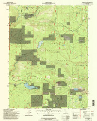
1995 Map of Jonesville
USGS Topo · Published 1998About this map
Jonesville serves as a primary point of interest in this high-altitude landscape where the boundaries of Butte, Plumas, and Tehama counties converge. Set within the Lassen National Forest, the area is defined by its recreation and natural resource history, featuring the Jonesville Snowmobile Park and the expansive Philbrook Reservoir. The terrain is marked by significant peaks such as Snow Mountain and Cherry Hill, while the Pacific Crest National Scenic Trail traverses the eastern ridges near Humbug Summit.
Find a feature on this map
52 named features on this map. Tap any name to fly to it.
Don’t see what you’re looking for? This feature index may not catch every label — zoom into the map to look around manually.
Map Details
Editions of this 1995 Jonesville Map
This is the sole edition of this map. No revisions or reprints were ever made.
Other maps of this area

1886 · Lassen Peak
USGS Topo · 1:250,000

1888 · Bidwell Bar
USGS Topo · 1:125,000

1891 · Bidwell Bar
USGS Topo · 1:125,000

1891 · Chico
USGS Topo · 1:125,000

1892 · Lassen Peak
USGS Topo · 1:250,000

1893 · Chico
USGS Topo · 1:125,000

1893 · Bidwell Bar
USGS Topo · 1:125,000

1894 · Lassen Peak
USGS Topo · 1:250,000

1895 · Bidwell Bar
USGS Topo · 1:125,000

1895 · Chico
USGS Topo · 1:125,000