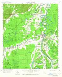
1960 Map of Jonesville
USGS Topo · Published 1965About this map
The confluence of the Ouachita River, Tensas River, and Little River at Jonesville defines this water-driven landscape of the Louisiana delta. This mid-century survey reveals a region deeply tied to its hydrology, where settlements like Trinity and Wildsville sit amidst an intricate network of secondary waterways, including Gin Slough, Bushley Bayou, and Honey Bayou. The presence of Indian Mounds near Jonesville indicates a long history of human habitation at this strategic river junction. For those researching local families, the map identifies several rural landmarks such as Salem Church, Young Cemetery, and New Mt Olive Church. Beyond agriculture and timber, the economy is marked by scattered Oil Wells and a significant Oil Field east of the Ouachita, while the Landing Field at Jonesville suggests growing postwar connectivity for this river-dependent community.
Find a feature on this map
138 named features on this map. Tap any name to fly to it.
Don’t see what you’re looking for? This feature index may not catch every label — zoom into the map to look around manually.
Map Details
Editions of this 1960 Jonesville Map
2 editions found

Other maps of this area

1935 · Tooleys
USGS Topo · 1:62,500

1939 · Red Gum
USGS Topo · 1:62,500

1939 · Deer Park
USGS Topo · 1:62,500

1941 · Manifest
USGS Topo · 1:62,500

1941 · Sicily Island
USGS Topo · 1:62,500

1941 · Jena
USGS Topo · 1:62,500

1941 · Buckeye
USGS Topo · 1:62,500

1941 · Tooleys
USGS Topo · 1:62,500

1941 · Harrisonburg
USGS Topo · 1:62,500

1953 · Alexandria
USGS Topo · 1:250,000