
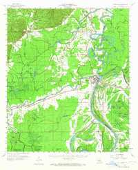
1960 Map of Jonesville
USGS Topo · Published 1961About this map
The confluence of the Quachita River, Tensas River, and Little River creates a complex aquatic landscape centered on the town of Jonesville. In the early 1960s, this region was defined by its relationship with these shifting waterways and the low-lying wetlands that separate them. The settlement at Trinity sits directly across the water from Jonesville, while rural life is mapped through a network of country churches such as Meyers Bend Ch and Pleasant Grove Ch.
Find a feature on this map
131 named features on this map. Tap any name to fly to it.
Don’t see what you’re looking for? This feature index may not catch every label — zoom into the map to look around manually.
Map Details
Editions of this 1960 Jonesville Map
2 editions found
Other maps of this area

1935 · Tooleys
USGS Topo · 1:62,500

1939 · Red Gum
USGS Topo · 1:62,500

1939 · Deer Park
USGS Topo · 1:62,500

1941 · Manifest
USGS Topo · 1:62,500

1941 · Sicily Island
USGS Topo · 1:62,500

1941 · Jena
USGS Topo · 1:62,500

1941 · Buckeye
USGS Topo · 1:62,500

1941 · Tooleys
USGS Topo · 1:62,500

1941 · Harrisonburg
USGS Topo · 1:62,500

1953 · Alexandria
USGS Topo · 1:250,000