
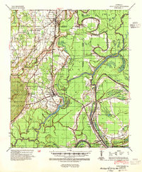
1941 Map of Sicily Island
USGS Topo · Published 1943About this map
Sicily Island rises as a prominent landform above the surrounding alluvial lowlands of the Mississippi River valley during the early 1940s. This survey by the Mississippi River Commission reveals a landscape defined by an intricate network of waterways, including Bayou Macon, the Tensas River, and Big Choctaw Bayou. The Missouri Pacific railroad cuts through the heart of the region, connecting the primary settlement at Sicily Island to northern points like Wisner.
Find a feature on this map
97 named features on this map. Tap any name to fly to it.
Don’t see what you’re looking for? This feature index may not catch every label — zoom into the map to look around manually.
Map Details
Editions of this 1941 Sicily Island Map
2 editions found
Other maps of this area

1921 · Natchez
USGS Topo · 1:48,000

1922 · Natchez
USGS Topo · 1:62,500

1935 · Winnsboro
USGS Topo · 1:62,500

1935 · Shackleford Lake
USGS Topo · 1:62,500

1939 · Red Gum
USGS Topo · 1:62,500

1939 · Fort Necessity
USGS Topo · 1:62,500

1939 · Natchez
USGS Topo · 1:62,500

1939 · Locust Ridge
USGS Topo · 1:62,500

1941 · Manifest
USGS Topo · 1:62,500

1941 · Harrisonburg
USGS Topo · 1:62,500