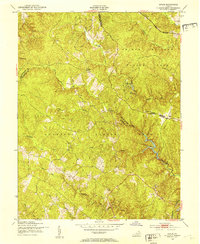
1951 Map of Joplin
USGS Topo · Published 1953About this map
The boundary between Prince William Co and Stafford Co defines the rugged geography of this 1951 survey, a landscape increasingly shaped by federal administration. Large portions of the territory are dedicated to the Prince William Forest Park and the Quantico Marine Base, including a designated Impact Area. Within the forest park, recreational developments like Camp No 2 and Camp No 5 appear alongside the older rural signatures of the region. Local life centers on the crossroads at Joplin and Kopp, with Mt Zion Ch serving the community near the park boundary. The land is heavily dissected by the headwaters of the South Fork Quantico Creek and its many branches, illustrating the difficult terrain that characterizes this part of Northern Virginia before modern suburban expansion.
Find a feature on this map
23 named features on this map. Tap any name to fly to it.
Don’t see what you’re looking for? This feature index may not catch every label — zoom into the map to look around manually.
Map Details
Editions of this 1951 Joplin Map
This is the sole edition of this map. No revisions or reprints were ever made.
Other maps of this area

1887 · Spottsylvania
USGS Topo · 1:125,000

1889 · Fredericksburg
USGS Topo · 1:125,000

1890 · Mt. Vernon
USGS Topo · 1:125,000

1891 · Mt. Vernon
USGS Topo · 1:125,000

1892 · Fredericksburg
USGS Topo · 1:125,000

1892 · Spottsylvania
USGS Topo · 1:125,000

1894 · Warrenton
USGS Topo · 1:125,000

1894 · Fredericksburg
USGS Topo · 1:125,000

1894 · Mt. Vernon
USGS Topo · 1:125,000

1897 · Mt. Vernon
USGS Topo · 1:125,000