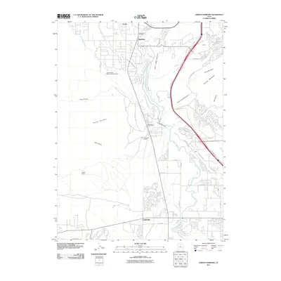
2011 Map of Jordan Narrows
USGS Topo · Published 2011About this map
Bluffdale sits at the northern end of this geographic bottleneck where the Jordan River carves through the Jordan Narrows between the Traverse Mountains and Steep Mountain. The landscape is defined by an intricate network of early 21st-century water infrastructure designed to move resources through the Salt Lake Valley, including the Utah Lake Distributing Canal, Utah and Salt Lake Canal, and Provo Reservoir Canal. These man-made waterways parallel the natural river course, reflecting the region's long-standing reliance on irrigation and water management.
Find a feature on this map
49 named features on this map. Tap any name to fly to it.
Don’t see what you’re looking for? This feature index may not catch every label — zoom into the map to look around manually.
Map Details
Editions of this 2011 Jordan Narrows Map
This is the sole edition of this map. No revisions or reprints were ever made.
Other maps of this area

1885 · Salt Lake
USGS Topo · 1:250,000

1885 · Tooele Valley
USGS Topo · 1:250,000

1915 · Fairfield
USGS Topo · 1:62,500

1917 · Fairfield
USGS Topo · 1:62,500

1925 · Ft. Douglas
USGS Topo · 1:125,000

1928 · Ft. Douglas
USGS Topo · 1:125,000

1950 · Pelican Point
USGS Topo · 1:24,000
1951 · Pelican Point
USGS Topo · 1:24,000

1951 · Jordan Narrows
USGS Topo · 1:24,000
1951 · Saratoga Springs
USGS Topo · 1:24,000