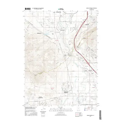
2017 Map of Jordan Narrows
USGS Topo · Published 2017About this map
The Jordan River carves through the gap between the Traverse Mountains and the Wasatch Range, creating a critical corridor for transport and water management in the Salt Lake Valley. This landscape is defined by its extensive network of irrigation and water works, including the Murdock Canal, Utah and Salt Lake Canal, and the Jordan Valley Water Purification Reservoir. These features underscore the region's long-standing engineering efforts to divert water for the growing communities of Bluffdale, Lehi, and Saratoga Springs.
Find a feature on this map
52 named features on this map. Tap any name to fly to it.
Don’t see what you’re looking for? This feature index may not catch every label — zoom into the map to look around manually.
Map Details
Editions of this 2017 Jordan Narrows Map
This is the sole edition of this map. No revisions or reprints were ever made.
Other maps of this area

1885 · Salt Lake
USGS Topo · 1:250,000

1885 · Tooele Valley
USGS Topo · 1:250,000

1915 · Fairfield
USGS Topo · 1:62,500

1917 · Fairfield
USGS Topo · 1:62,500

1925 · Ft. Douglas
USGS Topo · 1:125,000

1928 · Ft. Douglas
USGS Topo · 1:125,000

1950 · Pelican Point
USGS Topo · 1:24,000
1951 · Pelican Point
USGS Topo · 1:24,000

1951 · Jordan Narrows
USGS Topo · 1:24,000
1951 · Saratoga Springs
USGS Topo · 1:24,000