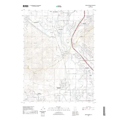
2020 Map of Jordan Narrows
USGS Topo · Published 2020About this map
The Jordan River carves a critical path through the landscape of the Jordan Narrows, a strategic geographical bottleneck where the Traverse Mountains meet the Wasatch Range. This survey documents a period of rapid infrastructure development along the Salt Lake County and Utah County border, marked by an intricate network of water management features including the Provo Reservoir Canal, Murdock Canal, and the Utah Lake Distributing Canal. Settlement expansion is evident in the residential growth of Bluffdale and Saratoga Springs, while the inclusion of the FrontRunner rail line and the Lehi Rail Trail reflects the area's transition toward modern transit and recreation. The map also identifies the Utah Veterans Cem and Memorial Park, situated near the prominent Point of the Mtn, a landmark central to the region's topography.
Find a feature on this map
40 named features on this map. Tap any name to fly to it.
Don’t see what you’re looking for? This feature index may not catch every label — zoom into the map to look around manually.
Map Details
Editions of this 2020 Jordan Narrows Map
This is the sole edition of this map. No revisions or reprints were ever made.
Other maps of this area

1885 · Salt Lake
USGS Topo · 1:250,000

1885 · Tooele Valley
USGS Topo · 1:250,000

1915 · Fairfield
USGS Topo · 1:62,500

1917 · Fairfield
USGS Topo · 1:62,500

1925 · Ft. Douglas
USGS Topo · 1:125,000

1928 · Ft. Douglas
USGS Topo · 1:125,000

1950 · Pelican Point
USGS Topo · 1:24,000
1951 · Pelican Point
USGS Topo · 1:24,000

1951 · Jordan Narrows
USGS Topo · 1:24,000
1951 · Saratoga Springs
USGS Topo · 1:24,000