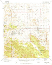
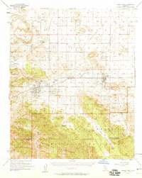
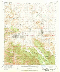
1955 Map of Joshua Tree
USGS Topo · Published 1957About this map
Joshua Tree and the emerging community of Yucca Valley sit along the Twenty Nine Palms Highway in this mid-century desert survey. The map details a period of post-war development in the high desert, featuring the western-themed enclave of Pioneertown and the religious landmark Desert-Christ Park. South of the San Bernardino Base Line, the landscape transitions into the protected terrain of Joshua Tree National Monument, where the Little San Bernardino Mountains dominate the horizon.
Find a feature on this map
30 named features on this map. Tap any name to fly to it.
Don’t see what you’re looking for? This feature index may not catch every label — zoom into the map to look around manually.
Map Details
Editions of this 1955 Joshua Tree Map
3 editions found
Other maps of this area

1901 · Southern California Sheet No. 1
USGS Topo · 1:250,000

1901 · San Jacinto
USGS Topo · 1:125,000

1902 · San Gorgonio
USGS Topo · 1:125,000

1904 · Southern California Sheet No. 1
USGS Topo · 1:250,000

1940 · Palm Springs
USGS Topo · 1:62,500

1941 · Edom
USGS Topo · 1:62,500
1944 · Palm Springs
USGS Topo · 1:62,500

1944 · Edom
USGS Topo · 1:62,500

1944 · Pinyon Well
USGS Topo · 1:62,500

1947 · Santa Ana
USGS Topo · 1:250,000