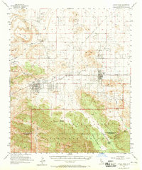
1955 Map of Joshua Tree
USGS Topo · Published 1965About this map
The high desert landscape of Yucca Valley and Joshua Tree is captured here during a period of mid-century growth. The map illustrates the emerging street grids of these desert communities, punctuated by landmarks such as Desert Christ Park and a local Landing Strip. To the north, the terrain transitions into the Sawtooths and the volcanic prominence of Lava Butte, while to the south, the vast wilderness of the Joshua Tree National Monument begins.
Find a feature on this map
42 named features on this map. Tap any name to fly to it.
Don’t see what you’re looking for? This feature index may not catch every label — zoom into the map to look around manually.
Map Details
Editions of this 1955 Joshua Tree Map
3 editions found

Other maps of this area

1901 · Southern California Sheet No. 1
USGS Topo · 1:250,000

1901 · San Jacinto
USGS Topo · 1:125,000

1902 · San Gorgonio
USGS Topo · 1:125,000

1904 · Southern California Sheet No. 1
USGS Topo · 1:250,000

1940 · Palm Springs
USGS Topo · 1:62,500

1941 · Edom
USGS Topo · 1:62,500

1944 · Palm Springs
USGS Topo · 1:62,500

1944 · Edom
USGS Topo · 1:62,500

1944 · Pinyon Well
USGS Topo · 1:62,500

1947 · Santa Ana
USGS Topo · 1:250,000