1944 Map of Palm Springs
USGS Topo · Published 1944About this map
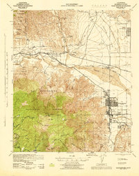
The Coachella Valley and the steep eastern face of the San Jacinto Mountains define this mid-century landscape. This 1944 survey captures Palm Springs as it emerges from the valley floor, organized around a grid of streets like Alejo Road and Roman Road within the Agua Caliente Indian Reservation. To the north, the Southern Pacific railroad traverses the San Gorgonio Pass, connecting Whitewater to Garnet Station while skirting the Morongo Indian Reservation.
Find a feature on this map
43 named features on this map. Tap any name to fly to it.
Don’t see what you’re looking for? This feature index may not catch every label — zoom into the map to look around manually.
Map Details
Editions of this 1944 Palm Springs Map
This is the sole edition of this map. No revisions or reprints were ever made.
Other maps of this area

1901 · Southern California Sheet No. 1
USGS Topo · 1:250,000

1901 · San Jacinto
USGS Topo · 1:125,000

1902 · San Gorgonio
USGS Topo · 1:125,000

1904 · Indio
USGS Topo · 1:125,000

1904 · Southern California Sheet No. 1
USGS Topo · 1:250,000

1940 · Palm Springs
USGS Topo · 1:62,500

1940 · Hemet Reservoir
USGS Topo · 1:62,500

1941 · Toro Peak
USGS Topo · 1:62,500

1941 · Edom
USGS Topo · 1:62,500

1942 · Banning
USGS Topo · 1:62,500