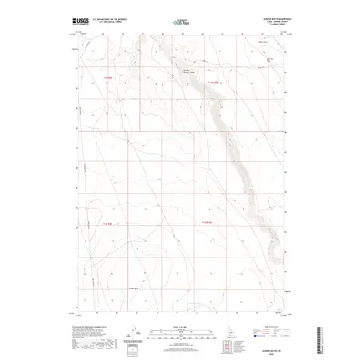
2020 Map of Juniper Butte
USGS Topo · Published 2020About this map
Juniper Butte dominates the southern landscape of this high desert region in Owyhee County. The terrain is defined by deep incisions in the plateau, most notably the East Fork Bruneau Canyon which cuts through the northern sections. This topography dictates the movement of water and travel, with drainage features like Clover Cr and Juniper Lake providing rare water sources in an otherwise arid environment. Transportation through this remote section of Idaho relies on established routes such as Three Creek Rd and primitive paths like Scotch Trl and Malat Trl. The map also details several named topographic depressions including Buck Flat Draw and Aikers Draw, which illustrate the complex erosion patterns common to the volcanic soils of the Owyhee plateau.
Find a feature on this map
13 named features on this map. Tap any name to fly to it.
Don’t see what you’re looking for? This feature index may not catch every label — zoom into the map to look around manually.
Map Details
Editions of this 2020 Juniper Butte Map
This is the sole edition of this map. No revisions or reprints were ever made.
Other maps of this area

1955 · Twin Falls
USGS Topo · 1:250,000

1958 · Twin Falls
USGS Topo · 1:250,000

1979 · Salls Crossing
USGS Topo · 1:24,000

1979 · Clover Butte South
USGS Topo · 1:24,000

1979 · Mosquito Lake Butte
USGS Topo · 1:24,000
1979 · Poison Butte
USGS Topo · 1:24,000

1979 · Coonskin Butte
USGS Topo · 1:24,000

1980 · Juniper Butte
USGS Topo · 1:24,000

1980 · Clover Butte North
USGS Topo · 1:24,000
1980 · Juniper Ranch
USGS Topo · 1:24,000