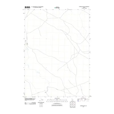
2010 Map of Juniper Ranch
USGS Topo · Published 2010About this map
Juniper Ranch and Clover Flat Ranch anchor this landscape in Owyhee County, illustrating the enduring nature of high-desert ranching in southern Idaho. The area is defined by the winding course of Clover Creek and the low-lying Buck Flat Draw, where the natural topography dictates the placement of isolated homesteads and essential water sources. In 2010, the transportation network relied on remote tracks like the Scotch Trl and Clover Rd, which link these distant outposts across the sagebrush-dominated terrain. This map provides a precise view of the rural infrastructure and land use patterns that have sustained local agriculture for generations, marking the intersection of natural drainage and human settlement in a corner of the state where space and distance remain the primary features.
Find a feature on this map
7 named features on this map. Tap any name to fly to it.
Don’t see what you’re looking for? This feature index may not catch every label — zoom into the map to look around manually.
Map Details
Editions of this 2010 Juniper Ranch Map
This is the sole edition of this map. No revisions or reprints were ever made.
Other maps of this area

1955 · Twin Falls
USGS Topo · 1:250,000

1956 · Blue Butte
USGS Topo · 1:62,500

1958 · Twin Falls
USGS Topo · 1:250,000

1959 · Crows Nest
USGS Topo · 1:62,500

1979 · Clover Butte South
USGS Topo · 1:24,000

1979 · Coonskin Butte
USGS Topo · 1:24,000

1980 · Juniper Butte
USGS Topo · 1:24,000
1980 · Crows Nest
USGS Topo · 1:24,000

1980 · Clover Butte North
USGS Topo · 1:24,000
1980 · Juniper Ranch
USGS Topo · 1:24,000