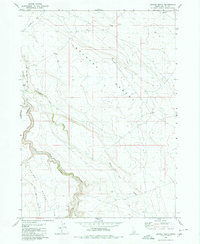
1980 Map of Juniper Ranch
USGS Topo · Published 1980About this map
The East Fork Bruneau River cuts a deep canyon through the high plateau of Owyhee County, separating the expansive Bruneau Desert to the northeast from the Inside Desert to the southwest. This arid landscape is sparsely settled, defined by remote outposts like Clover Flat Ranch and Juniper Ranch that anchor the local grazing economy. Surface water is a rare and vital resource, represented by the winding Clover Creek and intermittent drainage systems such as Buck Flat Draw. The infrastructure of the era is minimal, consisting primarily of the Clover Three Creek Road and various Jeep Trails that navigate the rimrock and sagebrush. A strategically placed Water Tank further emphasizes the reliance on managed water sources for livestock in this high-desert environment during the late 1970s.
Find a feature on this map
11 named features on this map. Tap any name to fly to it.
Don’t see what you’re looking for? This feature index may not catch every label — zoom into the map to look around manually.
Map Details
Editions of this 1980 Juniper Ranch Map
This is the sole edition of this map. No revisions or reprints were ever made.
Other maps of this area

1955 · Twin Falls
USGS Topo · 1:250,000

1956 · Blue Butte
USGS Topo · 1:62,500

1958 · Twin Falls
USGS Topo · 1:250,000

1959 · Crows Nest
USGS Topo · 1:62,500

1979 · Clover Butte South
USGS Topo · 1:24,000

1979 · Coonskin Butte
USGS Topo · 1:24,000

1980 · Juniper Butte
USGS Topo · 1:24,000
1980 · Crows Nest
USGS Topo · 1:24,000

1980 · Clover Butte North
USGS Topo · 1:24,000
1980 · Crows Nest Butte
USGS Topo · 1:24,000