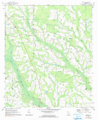
1971 Map of K'ville
USGS Topo · Published 1991About this map
K'Ville and the surrounding pine-dotted lowlands of Appling County are defined by a network of rural churches and family cemeteries at the start of the 1970s. The landscape is heavily dissected by the winding tributaries of Big Satilla Creek and Colemans Creek, where the terrain creates a mosaic of wetlands and ridges. Small community centers are anchored by landmarks like Morris Chapel, Christian Springs Ch, and Big Creek Ch, illustrating the distributed nature of settlement in this part of Georgia.
Find a feature on this map
25 named features on this map. Tap any name to fly to it.
Don’t see what you’re looking for? This feature index may not catch every label — zoom into the map to look around manually.
Map Details
Editions of this 1971 K'ville Map
2 editions found
Other maps of this area

1953 · Waycross
USGS Topo · 1:250,000

1958 · Waycross
USGS Topo · 1:250,000
1971 · Odum
USGS Topo · 1:24,000

1971 · Surrency
USGS Topo · 1:24,000
1971 · Ritch
USGS Topo · 1:24,000

1971 · Coffee
USGS Topo · 1:24,000

1971 · K'ville
USGS Topo · 1:24,000

1971 · Patterson
USGS Topo · 1:24,000
1971 · Screven
USGS Topo · 1:24,000

1971 · Mershon
USGS Topo · 1:24,000