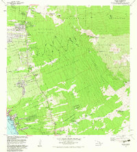
1982 Map of Kailua
USGS Topo · Published 1983About this map
The coastline of Kailua Bay and Oneo Bay serves as the focal point for this 1980s coastal survey, depicting the transition from the bustling hub of Kailua to the mauka agricultural and forest lands. The map illustrates a complex system of land divisions, including numerous numbered homesteads like the Kalaoa 1 through Kalaoa 5 series and the Kealakehe Homesteads (1st Series). These traditional and colonial land patterns stretch inland toward the Honuaula Forest Reserve, reflecting the historic Kona land tenure system where narrow strips extended from the sea to the uplands.
Find a feature on this map
77 named features on this map. Tap any name to fly to it.
Don’t see what you’re looking for? This feature index may not catch every label — zoom into the map to look around manually.
Map Details
Editions of this 1982 Kailua Map
This is the sole edition of this map. No revisions or reprints were ever made.
Other maps of this area

1928 · Puako
USGS Topo · 1:62,500

1928 · Kailua
USGS Topo · 1:62,500

1954 · Hawaii North
USGS Topo · 1:250,000

1959 · Hawaii North
USGS Topo · 1:250,000

1959 · Kiholo
USGS Topo · 1:24,000

1959 · Hualalai
USGS Topo · 1:24,000

1959 · Puu Lehua
USGS Topo · 1:24,000

1959 · Makalawena
USGS Topo · 1:24,000

1959 · Keahole Point
USGS Topo · 1:24,000
1959 · Puu Anahulu
USGS Topo · 1:24,000