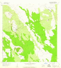
1959 Map of Puu Anahulu
USGS Topo · Published 1960About this map
The volcanic terrain of Hawaii's Big Island dominates this 1959 survey, where the massive Lava Flow of 1859 and the Kaniku Lava Flow cut distinct paths across the landscape. The human presence is centered at the Puu Waawaa Ranch and the settlement of Puu Anahulu, which are connected by the Mamalahoa Highway. Notable land use is evident in the Puu Anahulu Homesteads and specialized agricultural features like the Molasses Tank and Rain Shed near the ranch. The map documents numerous cinder cones or "puus," including Puu Waawaa, Puu Kukai, and Puu Haole, which serve as landmarks in this geologically active region. Genealogy and local history researchers will find the Graves location and the district boundary between South Kohala and North Kona useful for pinpointing specific early 20th-century family locations and property lines.
Find a feature on this map
51 named features on this map. Tap any name to fly to it.
Don’t see what you’re looking for? This feature index may not catch every label — zoom into the map to look around manually.
Map Details
Editions of this 1959 Puu Anahulu Map
2 editions found
Other maps of this area

1927 · Kaohe
USGS Topo · 1:62,500

1928 · Puako
USGS Topo · 1:62,500

1928 · Kailua
USGS Topo · 1:62,500

1930 · Kaohe
USGS Topo · 1:62,500

1954 · Hawaii North
USGS Topo · 1:250,000

1956 · Puu Hinai
USGS Topo · 1:24,000

1956 · Keamuku
USGS Topo · 1:24,000

1956 · Nohonaohae
USGS Topo · 1:24,000

1956 · Naohueleelua
USGS Topo · 1:24,000

1959 · Hawaii North
USGS Topo · 1:250,000