
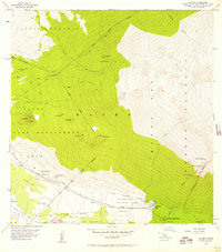
1956 Map of Keamuku
USGS Topo · Published 1957About this map
The Keamuku Lava Flow dominates this high-altitude landscape on the Big Island, illustrating the volcanic foundations of Hawaii's ranching and game lands in the mid-1950s. The small settlements of Waikii and Keamuku serve as anchors in an area defined by district boundaries and vast management tracts like the Waikii Paddock Game Management Area. Notable landmarks including the Kilohana Girl Scout Camp are situated amongst a series of cinder cones, or puu, such as Puu Kahekili and Puu Keekee. The network of water tanks, fences, and pipelines shown here highlights the intensive infrastructure required for land use in this arid, porous terrain. Major transit routes like the Mamalahoa Highway and Saddle Road provide access through the complex geography of gulches and lava fields, including the Kaohe Lava Flow reaching into the Mauna Loa Forest and Game Reserve.
Find a feature on this map
30 named features on this map. Tap any name to fly to it.
Don’t see what you’re looking for? This feature index may not catch every label — zoom into the map to look around manually.
Map Details
Editions of this 1956 Keamuku Map
This is the sole edition of this map. No revisions or reprints were ever made.
Other maps of this area

1927 · Kaohe
USGS Topo · 1:62,500

1928 · Puako
USGS Topo · 1:62,500

1928 · Kailua
USGS Topo · 1:62,500

1930 · Kaohe
USGS Topo · 1:62,500

1954 · Hawaii North
USGS Topo · 1:250,000

1956 · Puu Koli
USGS Topo · 1:24,000

1956 · Puu Hinai
USGS Topo · 1:24,000

1956 · Nohonaohae
USGS Topo · 1:24,000

1956 · Makahalau
USGS Topo · 1:24,000
1956 · Ahumoa
USGS Topo · 1:24,000