
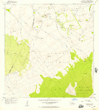
1956 Map of Makahalau
USGS Topo · Published 1957About this map
The high slopes of the Big Island's volcanic interior define this 1950s survey, marking the transition from ranching lands to the Mauna Kea Forest Reserve. Small settlements like Mana and Makahalau are centers of activity in this upland landscape, supported by a specialized infrastructure of water management. Numerous pump stations, including the Makahalau Pump Station and Puu Io Pump Station, along with various troughs and tanks, illustrate the necessity of piped water in this porous volcanic terrain.
Find a feature on this map
42 named features on this map. Tap any name to fly to it.
Don’t see what you’re looking for? This feature index may not catch every label — zoom into the map to look around manually.
Map Details
Editions of this 1956 Makahalau Map
2 editions found
Other maps of this area

1915 · Hamakua
USGS Topo · 1:62,500

1916 · Waipio
USGS Topo · 1:62,500

1954 · Hawaii North
USGS Topo · 1:250,000

1956 · Kamuela
USGS Topo · 1:24,000

1956 · Keamuku
USGS Topo · 1:24,000

1956 · Nohonaohae
USGS Topo · 1:24,000
1956 · Ahumoa
USGS Topo · 1:24,000

1956 · Mauna Kea
USGS Topo · 1:24,000

1956 · Umikoa
USGS Topo · 1:24,000

1957 · Honokaa
USGS Topo · 1:24,000