
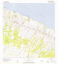
1957 Map of Honokaa
USGS Topo · Published 1959About this map
Deep ravines and steep gulches carve through the coastal landscape of Hawaii's Hamakua District, where early sugar era settlements like Haina and Paauhau cling to the bluffs above the Pacific Ocean. The infrastructure of a productive agricultural economy is evident in the network of flumes, ditches, and landing strips that supported the sugarcane fields and homesteads. Local life centers on the town of Honokaa, home to the Honokaa Hospital and a Rodeo Arena, while the southern reaches of the map climb toward the dense wilderness of the Hamakua Forest Reserve. This terrain required unique transport solutions, seen in labels like Paauhau Landing and Honokaa Landing, which provided essential maritime access before modern road networks were fully realized. Numerous homestead tracts, including Paauilo Homesteads and Kaapahu Homesteads, reveal the pattern of land division and settlement during this mid-century period.
Find a feature on this map
53 named features on this map. Tap any name to fly to it.
Don’t see what you’re looking for? This feature index may not catch every label — zoom into the map to look around manually.
Map Details
Editions of this 1957 Honokaa Map
2 editions found
Other maps of this area

1915 · Hamakua
USGS Topo · 1:62,500

1916 · Waipio
USGS Topo · 1:62,500

1954 · Hawaii North
USGS Topo · 1:250,000

1956 · Keanakolu
USGS Topo · 1:24,000

1956 · Makahalau
USGS Topo · 1:24,000

1956 · Umikoa
USGS Topo · 1:24,000

1957 · Kukaiau
USGS Topo · 1:24,000

1959 · Hawaii North
USGS Topo · 1:250,000

1961 · Hawaii North
USGS Topo · 1:250,000

1975 · Hawaii
USGS Topo · 1:250,000