
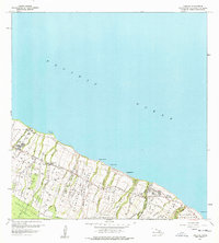
1957 Map of Kukaiau
USGS Topo · Published 1959About this map
The Hamakua Forest Reserve and the coastal settlements of the Hamakua Coast define this mid-century survey. The landscape is deeply carved by numerous parallel gulches and streams flowing from the volcanic slopes to the Pacific Ocean, including the Koholaiele Gulch and Kaala Stream. This topography dictated the development of the region's infrastructure, seen here in the Old Railroad Grade and the Mamalahoa Highway that bridge the many ravines.
Find a feature on this map
48 named features on this map. Tap any name to fly to it.
Don’t see what you’re looking for? This feature index may not catch every label — zoom into the map to look around manually.
Map Details
Editions of this 1957 Kukaiau Map
2 editions found
Other maps of this area

1915 · Hamakua
USGS Topo · 1:62,500

1915 · Honomu
USGS Topo · 1:62,500

1954 · Hawaii North
USGS Topo · 1:250,000

1956 · Keanakolu
USGS Topo · 1:24,000

1956 · Umikoa
USGS Topo · 1:24,000

1957 · Honokaa
USGS Topo · 1:24,000

1959 · Hawaii North
USGS Topo · 1:250,000

1961 · Hawaii North
USGS Topo · 1:250,000
1966 · Papaaloa
USGS Topo · 1:24,000

1975 · Hawaii
USGS Topo · 1:250,000