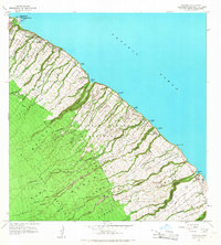
1966 Map of Papaaloa
USGS Topo · Published 1968About this map
The Hamakua Coast of Hawaii Island is defined by steep gulches and high coastal bluffs, as seen in this mid-1960s survey. The settlement of Laupahoehoe sits prominently on the shoreline, where the Tidal Wave Memorial serves as a somber reminder of the 1946 tsunami. Moving inland, the land rises sharply toward the Hilo Forest Reserve, cut by numerous parallel drainage systems including Laupahoehoe Stream and Maulua Stream.
Find a feature on this map
64 named features on this map. Tap any name to fly to it.
Don’t see what you’re looking for? This feature index may not catch every label — zoom into the map to look around manually.
Map Details
Editions of this 1966 Papaaloa Map
This is the sole edition of this map. No revisions or reprints were ever made.
Other maps of this area

1915 · Hamakua
USGS Topo · 1:62,500

1915 · Honomu
USGS Topo · 1:62,500

1954 · Hawaii North
USGS Topo · 1:250,000

1956 · Pua Akala
USGS Topo · 1:24,000

1956 · Keanakolu
USGS Topo · 1:24,000

1957 · Kukaiau
USGS Topo · 1:24,000

1959 · Hawaii North
USGS Topo · 1:250,000

1961 · Hawaii North
USGS Topo · 1:250,000
1966 · Akaka Falls
USGS Topo · 1:24,000
1966 · Papaikou
USGS Topo · 1:24,000