
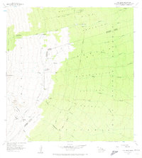
1956 Map of Pua Akala
USGS Topo · Published 1957About this map
Mauna Kea Forest Reserve and its adjacent timberlands define the upper slopes of the Hilo coast in the mid-1950s. This survey documents a transition from the volcanic heights of Puu Kahinahina and Aahuwela down through the dense drainage networks of the Maulua Forest Reserve and Piha Forest Reserve. The map records specific points of human habitation and utility on these high-altitude ranges, including the Kanakaleonui Ranger Station and the remote Nauhi Camp.
Find a feature on this map
38 named features on this map. Tap any name to fly to it.
Don’t see what you’re looking for? This feature index may not catch every label — zoom into the map to look around manually.
Map Details
Editions of this 1956 Pua Akala Map
2 editions found
Other maps of this area

1915 · Honomu
USGS Topo · 1:62,500

1917 · Hilo
USGS Topo · 1:62,500

1930 · Humuula
USGS Topo · 1:62,500

1932 · Hilo
USGS Topo · 1:62,500

1954 · Hawaii North
USGS Topo · 1:250,000

1956 · Puu Oo
USGS Topo · 1:24,000

1956 · Keanakolu
USGS Topo · 1:24,000

1956 · Upper Piihonua
USGS Topo · 1:24,000

1956 · Mauna Kea
USGS Topo · 1:24,000

1956 · Umikoa
USGS Topo · 1:24,000