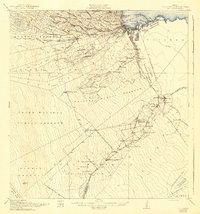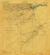
1917 Map of Hilo
USGS Topo · Published 1917About this map
The industrial and agricultural foundations of Hilo are clearly visible during the First World War, with the Waiakea Mill and Olaa Plantation Mill serving as major economic hubs. The landscape is defined by the massive Lava Flow of 1881 cutting across the South Hilo District, illustrating the persistent volcanic influence on settlement patterns. Inland, a network of plantation camps and small communities like Kurtistown and Mountain View follow the path of the Hilo R. R. and the main Volcano Road.
Find a feature on this map
82 named features on this map. Tap any name to fly to it.
Don’t see what you’re looking for? This feature index may not catch every label — zoom into the map to look around manually.
Map Details
Editions of this 1917 Hilo Map
This is the sole edition of this map. No revisions or reprints were ever made.
Historical Maps of Hilo Through Time
9 maps found