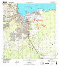
1995 Map of Hilo
USGS Topo · Published 1998About this map
The Lava Flow of 1881 cuts a prominent diagonal swath across the Hilo landscape, providing a physical record of the volcanic activity that shaped this coast. Near the shoreline, the map details the intersection of urban growth and natural features, from Coconut Island in Hilo Bay to the protected waters of Reeds Bay. The survey captures Hilo in a period of institutional expansion, featuring the University of Hawaii and the Hilo International Airport, while also documenting the agricultural and industrial foundations of the region. To the south, the Puna Sugar Company Mill and various camps such as 8 1/2 Mile Camp and Camp Six point to the area's plantation history. Extensive green spaces like the Panaewa Forest Reserve and Waiakea Forest Reserve buffer the developed homesteads from the surrounding terrain.
Find a feature on this map
69 named features on this map. Tap any name to fly to it.
Don’t see what you’re looking for? This feature index may not catch every label — zoom into the map to look around manually.
Map Details
Editions of this 1995 Hilo Map
This is the sole edition of this map. No revisions or reprints were ever made.
Other maps of this area

1915 · Honomu
USGS Topo · 1:62,500

1917 · Hilo
USGS Topo · 1:62,500

1924 · Makuu
USGS Topo · 1:62,500

1932 · Hilo
USGS Topo · 1:62,500

1954 · Hawaii North
USGS Topo · 1:250,000

1959 · Hawaii North
USGS Topo · 1:250,000

1961 · Hawaii North
USGS Topo · 1:250,000
1963 · Puu Makaala
USGS Topo · 1:24,000
1963 · Piihonua
USGS Topo · 1:24,000
1963 · Hilo
USGS Topo · 1:24,000