
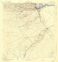
1932 Map of Hilo
USGS Topo · Published 1932About this map
Hilo and the surrounding sugar plantation country are documented here during the early 1930s, showing a landscape defined by the sugar industry and recent volcanic history. The Olaa Plantation Mill and Wainaku Mill anchor the local economy, supported by the Hilo R R and its Puna Branch which moved cane and supplies across the district. A network of plantation camps, including Camp Two through Camp Ten, illustrates the labor organization of the era, while infrastructure like the Olaa Flume and the Lower Plume House highlights the critical role of water management in the region's agricultural output.
Find a feature on this map
73 named features on this map. Tap any name to fly to it.
Don’t see what you’re looking for? This feature index may not catch every label — zoom into the map to look around manually.
Map Details
Editions of this 1932 Hilo Map
2 editions found
Other maps of this area

1915 · Honomu
USGS Topo · 1:62,500

1917 · Hilo
USGS Topo · 1:62,500

1921 · Kilauea
USGS Topo · 1:62,500

1922 · Puna
USGS Topo · 1:62,500

1924 · Makuu
USGS Topo · 1:62,500

1924 · Kilauea
USGS Topo · 1:62,500

1924 · Puna
USGS Topo · 1:62,500

1924 · Kalapana
USGS Topo · 1:62,500

1930 · Humuula
USGS Topo · 1:62,500

1954 · Hawaii South
USGS Topo · 1:250,000