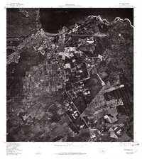
1977 Map of Hilo
USGS Topo · Published 1981About this map
Hilo is captured during a period of significant mid-century development in this 1977 orthophotoquad, which reveals the dense urban grid and coastal infrastructure of Hawaii's second-largest city. The aerial photography highlights the sharp contrast between the residential and commercial blocks of the city center and the expansive, dark lava fields and agricultural lands that surround the settlement. Along the northern edge, the protected waters of Hilo Bay meet the shoreline, revealing the harbor works and the breakwater that define the waterfront economy. This visual survey provides an overhead record of the city's growth, including the layout of the regional airport and the branching road networks that extend toward the upland forests and plantation lands.
Find a feature on this map
2 named features on this map. Tap any name to fly to it.
Don’t see what you’re looking for? This feature index may not catch every label — zoom into the map to look around manually.
Map Details
Editions of this 1977 Hilo Map
This is the sole edition of this map. No revisions or reprints were ever made.
Other maps of this area

1915 · Honomu
USGS Topo · 1:62,500

1917 · Hilo
USGS Topo · 1:62,500

1924 · Makuu
USGS Topo · 1:62,500

1932 · Hilo
USGS Topo · 1:62,500

1954 · Hawaii North
USGS Topo · 1:250,000

1959 · Hawaii North
USGS Topo · 1:250,000

1961 · Hawaii North
USGS Topo · 1:250,000
1963 · Puu Makaala
USGS Topo · 1:24,000
1963 · Piihonua
USGS Topo · 1:24,000
1963 · Hilo
USGS Topo · 1:24,000