
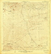
1930 Map of Humuula
USGS Topo · Published 1930About this map
Volcanic activity and high-altitude ranching define this territory at the base of the mountain, where the Lava Flow of 1843 and subsequent flows from 1852, 1855, and 1899 have carved a stark path through the native landscape. The Humuula Sheep Station and Puu Oo Ranch stand as isolated outposts of early 20th-century industry amidst a complex network of forest reserves, including the Hilo Forest Reserve and South Hilo Forest Reserve.
Find a feature on this map
45 named features on this map. Tap any name to fly to it.
Don’t see what you’re looking for? This feature index may not catch every label — zoom into the map to look around manually.
Map Details
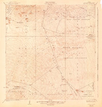
Editions of this 1930 Humuula Map
3 editions found
Other maps of this area

1915 · Honomu
USGS Topo · 1:62,500

1917 · Hilo
USGS Topo · 1:62,500

1921 · Kilauea
USGS Topo · 1:62,500

1922 · Puna
USGS Topo · 1:62,500

1924 · Kilauea
USGS Topo · 1:62,500

1924 · Puna
USGS Topo · 1:62,500

1927 · Kaohe
USGS Topo · 1:62,500

1928 · Mauna Loa
USGS Topo · 1:62,500

1930 · Kaohe
USGS Topo · 1:62,500

1932 · Hilo
USGS Topo · 1:62,500