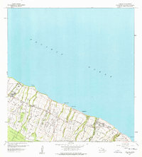
1957 Map of Kukaiau
USGS Topo · Published 1977About this map
Mamalahoa Highway winds across the Hamakua Coast in this mid-century survey, connecting a series of sugar-era settlements and agricultural homesteads. The landscape is defined by its deep, parallel gulches—such as Waipunalao Gulch and Gulch—that channel water from the Hamakua Forest Reserve toward the Pacific Ocean. This era shows a transition in local infrastructure, with the old railroad grade still visible along the bluffs while a landing strip appears near the coast.
Find a feature on this map
46 named features on this map. Tap any name to fly to it.
Don’t see what you’re looking for? This feature index may not catch every label — zoom into the map to look around manually.
Map Details
Editions of this 1957 Kukaiau Map
2 editions found
Other maps of this area

1915 · Hamakua
USGS Topo · 1:62,500

1915 · Honomu
USGS Topo · 1:62,500

1954 · Hawaii North
USGS Topo · 1:250,000

1956 · Keanakolu
USGS Topo · 1:24,000

1956 · Umikoa
USGS Topo · 1:24,000

1957 · Kukaiau
USGS Topo · 1:24,000

1957 · Honokaa
USGS Topo · 1:24,000

1959 · Hawaii North
USGS Topo · 1:250,000

1961 · Hawaii North
USGS Topo · 1:250,000
1966 · Papaaloa
USGS Topo · 1:24,000