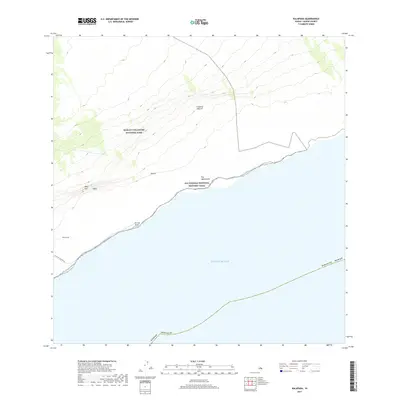
2017 Map of Kalapana
USGS Topo · Published 2017About this map
Hawai‘i Volcanoes National Park dominates this coastal section of the Island of Hawai‘i, where the steep descent of Hnlei Pali meets the edge of the Pacific Ocean. This 2017 survey documents the volatile landscape south of the Kilauea caldera, highlighting the intersection of geologic forces and cultural heritage. The Ala Kahakai National Historic Trail follows the shoreline through ancient coastal sites like Pu‘u Loa and Ka Lae Apuki, tracing a path that preserves the traditional Hawaiian footprints on the land. The presence of Chain Of Craters Rd indicates the primary modern access through this protected wilderness, winding past features such as Holei and Puu Manawalea. The map illustrates a dramatic vertical drop from the high volcanic interior toward the rugged cliffs of Paliuli, capturing the area's character as a site of continuous geophysical change.
Find a feature on this map
14 named features on this map. Tap any name to fly to it.
Don’t see what you’re looking for? This feature index may not catch every label — zoom into the map to look around manually.
Map Details
Editions of this 2017 Kalapana Map
This is the sole edition of this map. No revisions or reprints were ever made.
Other maps of this area

1922 · Puna
USGS Topo · 1:62,500

1924 · Puna
USGS Topo · 1:62,500

1924 · Kalapana
USGS Topo · 1:62,500

1954 · Hawaii South
USGS Topo · 1:250,000

1959 · Hawaii South
USGS Topo · 1:250,000

1961 · Hawaii South
USGS Topo · 1:250,000

1962 · Hawaii South
USGS Topo · 1:250,000
1963 · Volcano
USGS Topo · 1:24,000
1963 · Makaopuhi Crater
USGS Topo · 1:24,000
1966 · Pahoa South
USGS Topo · 1:24,000