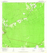
1963 Map of Volcano
USGS Topo · Published 1964About this map
The community of Volcano sits at the threshold of Kilauea's active volcanic landscape in this 1963 field-checked survey. The map details the transition from the dense tropical canopy of the surrounding forest reserves to the stark geological features of the summit area. Notable landmarks include the massive Kilauea Iki Crater and the nearby Thurston Lava Tube, illustrating the unique volcanic plumbing of the Big Island. To the northeast, the settlement of Glenwood is positioned along the transit corridor leading toward the coast. This record captures the human presence at the edge of the Hawaii Volcanoes National Park before decades of subsequent eruptions altered the local topography, documenting the benchmarks and roads as they existed in the early 1960s.
Find a feature on this map
4 named features on this map. Tap any name to fly to it.
Don’t see what you’re looking for? This feature index may not catch every label — zoom into the map to look around manually.
Map Details
Editions of this 1963 Volcano Map
This is the sole edition of this map. No revisions or reprints were ever made.
Other maps of this area

1917 · Hilo
USGS Topo · 1:62,500

1921 · Kilauea
USGS Topo · 1:62,500

1922 · Puna
USGS Topo · 1:62,500

1924 · Kilauea
USGS Topo · 1:62,500

1924 · Puna
USGS Topo · 1:62,500

1930 · Humuula
USGS Topo · 1:62,500

1932 · Hilo
USGS Topo · 1:62,500

1954 · Hawaii South
USGS Topo · 1:250,000

1954 · Hawaii North
USGS Topo · 1:250,000
1956 · Kulani
USGS Topo · 1:24,000