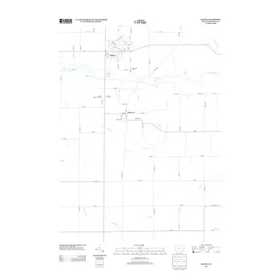
2013 Map of Kalona
USGS Topo · Published 2013About this map
Kalona serves as the primary hub of this eastern Iowa landscape, where the grid-like precision of rural road systems meets the meandering path of the English River. The river creates a natural corridor through the northern half of the map, fed by tributaries like Rumsey Cr and Bulgers Run, while the southern reaches are defined by drainage basins including Camp Cr and the N Fork Long Cr. Local landmarks such as the Windmill Ridge Camp Ground and Kalona Golf Course sit between the main settlement and the smaller community of Richmond to the south. This 2013 survey illustrates the enduring agricultural character of Washington County, marked by established operations like Banker Mill Dairy and a dense network of numbered gravel and paved roads that facilitate the movement of goods and people across the prairie.
Find a feature on this map
67 named features on this map. Tap any name to fly to it.
Don’t see what you’re looking for? This feature index may not catch every label — zoom into the map to look around manually.
Map Details
Editions of this 2013 Kalona Map
This is the sole edition of this map. No revisions or reprints were ever made.
Other maps of this area

1891 · Oxford
USGS Topo · 1:62,500

1891 · Iowa City
USGS Topo · 1:62,500

1894 · Oxford
USGS Topo · 1:62,500

1903 · Fairfax
USGS Topo · 1:125,000

1938 · Iowa City
USGS Topo · 1:62,500

1958 · Davenport
USGS Topo · 1:250,000

1961 · Davenport
USGS Topo · 1:250,000

1962 · Davenport
USGS Topo · 1:250,000

1965 · Williamstown
USGS Topo · 1:24,000
1965 · Hills
USGS Topo · 1:24,000