1946 Map of Kaplan
USGS Topo · Published 1946About this map
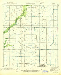
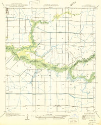
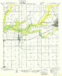
The boundary between Acadia Parish and Vermilion Parish follows the meandering course of Queue de Tortue and Bayou de Tortue in this mid-century survey of the southwest Louisiana prairies. The grid-like layout of the landscape is dominated by an extensive network of irrigation ditches and canals, including the Avrico Canal, reflecting the region's deep ties to rice cultivation. In the southeast, the town of Kaplan is shown with its emerging street grid and industrial footprint along the Southern Pacific railroad line.
Find a feature on this map
18 named features on this map. Tap any name to fly to it.
Don’t see what you’re looking for? This feature index may not catch every label — zoom into the map to look around manually.
Map Details
Editions of this 1946 Kaplan Map
This is the sole edition of this map. No revisions or reprints were ever made.
Other maps of this area

1932 · Abbeville NW
USGS Topo · 1:31,680

1934 · Duson
USGS Topo · 1:31,680
1946 · Morse
USGS Topo · 1:31,680

1946 · Leroy
USGS Topo · 1:31,680

1946 · Schooner Bayou NE
USGS Topo · 1:31,680

1946 · Schooner Bayou NW
USGS Topo · 1:31,680

1946 · Rayne
USGS Topo · 1:31,680
1949 · Estherwood
USGS Topo · 1:31,680

1952 · Lake Charles
USGS Topo · 1:250,000

1954 · Schooner Bayou NW
USGS Topo · 1:31,680