1954 Map of Kaplan
USGS Topo · Published 1954About this map
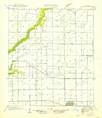
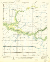
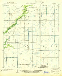
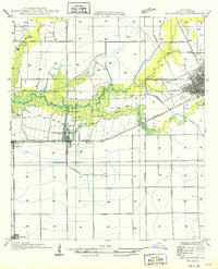
The town of Kaplan serves as the primary hub in this mid-century survey of the southwest Louisiana prairie. The landscape is defined by a dense network of agricultural drainage and irrigation, with long-established property lines and section boundaries crisscrossed by numerous canals and roads like State Highway No 26 and State Highway No 25. The meandering Queue de Tortue Bayou forms the natural boundary between Acadia Parish and Vermilion Parish, flanked by low-lying wetlands and the Bayou de Tortue. Local history is visible in the small settlements of Leleux and Cossinade, while the presence of the Apshire Cem provides a specific point of interest for genealogists. The Southern Pacific railroad runs through the heart of the region, anchoring the local economy to the broader transport network that once moved the area's agricultural products.
Find a feature on this map
18 named features on this map. Tap any name to fly to it.
Don’t see what you’re looking for? This feature index may not catch every label — zoom into the map to look around manually.
Map Details
Editions of this 1954 Kaplan Map
This is the sole edition of this map. No revisions or reprints were ever made.
Other maps of this area

1932 · Abbeville NW
USGS Topo · 1:31,680

1934 · Duson
USGS Topo · 1:31,680
1946 · Morse
USGS Topo · 1:31,680

1946 · Leroy
USGS Topo · 1:31,680

1946 · Schooner Bayou NE
USGS Topo · 1:31,680

1946 · Schooner Bayou NW
USGS Topo · 1:31,680
1946 · Kaplan
USGS Topo · 1:31,680

1946 · Rayne
USGS Topo · 1:31,680
1949 · Estherwood
USGS Topo · 1:31,680

1952 · Lake Charles
USGS Topo · 1:250,000