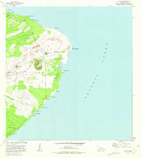
1981 Map of Kapoho
USGS Topo · Published 1981About this map
Lava Flow of 1960 and the Lava Flow of 1955 dominate this coastal survey of the Puna District, showing how volcanic activity reshaped the shoreline of East Hawaii. The map documents the easternmost point of the island at Cape Kumukahi, where a Light and the Kings Pillars stand near the edge of the Pacific. Cultural and archaeological sites are significant here, including the Kukii Heiau and Mahinaakaka Heiau, alongside evidence of traditional maritime life like the Old Hawaiian Canoe Sheds at Kalamanū. Inland, the landscape is defined by the East Rift Zone and the prominent Kapoho Crater, which contains Green Lake. The settlement patterns at Kapoho, Pohoiki, and Pualaa are shown as they existed in the early 1980s, intersected by the Pahoa Pohoiki Road and interspersed with numerous cinder pits.
Find a feature on this map
57 named features on this map. Tap any name to fly to it.
Don’t see what you’re looking for? This feature index may not catch every label — zoom into the map to look around manually.
Map Details
Editions of this 1981 Kapoho Map
This is the sole edition of this map. No revisions or reprints were ever made.
Other maps of this area

1924 · Makuu
USGS Topo · 1:62,500

1924 · Kalapana
USGS Topo · 1:62,500

1954 · Hawaii South
USGS Topo · 1:250,000

1954 · Hawaii North
USGS Topo · 1:250,000

1959 · Hawaii South
USGS Topo · 1:250,000

1959 · Hawaii North
USGS Topo · 1:250,000

1961 · Hawaii North
USGS Topo · 1:250,000

1961 · Hawaii South
USGS Topo · 1:250,000

1962 · Hawaii South
USGS Topo · 1:250,000
1965 · Pahoa North
USGS Topo · 1:24,000