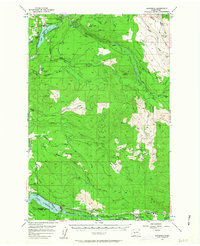
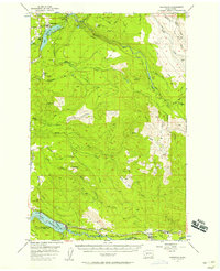
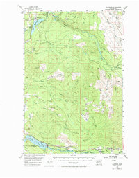
1956 Map of Kapowsin
USGS Topo · Published 1963About this map
Kapowsin Lake and the northern settlement of Kapowsin anchor this mid-century look at the timber and hydroelectric landscape of Pierce County. The Puyallup River system is heavily utilized for power generation, noted by the Powerhouse, Penstocks, and the Electron Res near Electron. This industrial infrastructure is mirrored in the south by the Alder Reservoir on the Nisqually River, where the Chicago Milwaukee St Paul and Pacific railroad tracks follow the riverbank through Elbe and National. The landscape is a patchwork of forested sections and cleared areas, reflecting the logging operations of the era. Smaller settlements like Ashford and Park Junction serve as gateways toward the mountain, while recreational spots such as Voss Resort and Surprise Valley dot the western edge of the quadrangle.
Find a feature on this map
53 named features on this map. Tap any name to fly to it.
Don’t see what you’re looking for? This feature index may not catch every label — zoom into the map to look around manually.
Map Details
Editions of this 1956 Kapowsin Map
Other maps of this area

1897 · Tacoma
USGS Topo · 1:125,000

1900 · Tacoma
USGS Topo · 1:125,000

1913 · Cedar Lake
USGS Topo · 1:125,000

1924 · Mt Rainier
USGS Topo · 1:96,000

1928 · Mt Rainier
USGS Topo · 1:125,000

1937 · Eatonville
USGS Topo · 1:125,000

1941 · Tanwax Lake
USGS Topo · 1:62,500

1941 · Tacoma South
USGS Topo · 1:62,500

1942 · Lake Tapps
USGS Topo · 1:62,500

1944 · Lake Tapps
USGS Topo · 1:62,500